Earth Science and Engineering
Fewer major earthquakes for the northern Dead Sea Fault
A new analytical technique enables reassessment of plate boundaries and improved slip rate estimations along the Dead Sea Fault.


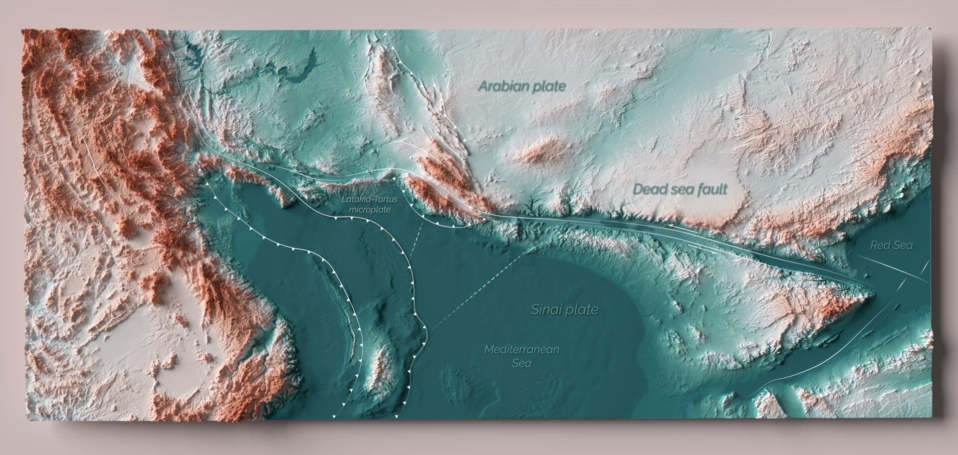
A new model for the Dead Sea Fault suggests that its northern section in Syria has a slip rate that is slower than previously thought, indicating it is experiencing less frequent major earthquakes.
This was identified using a refined analytical technique for satellite radar images in a study by Ph.D. graduate Xing Li along with her KAUST advisor Sigurjón Jónsson and collaborators. Their results suggest that this section moves only half as fast, which may be partly due to a “microplate” situated to the west of the northern Dead Sea Fault[1].
Large earthquakes usually stem from the movement of tectonic plates and the resulting build-up and release of stress as they slide past, under or over each other. The “slip rate” — or the measure of how two or more plates are moving with respect to each other over time — is an important factor contributing to the hazard of seismic activity in a region.
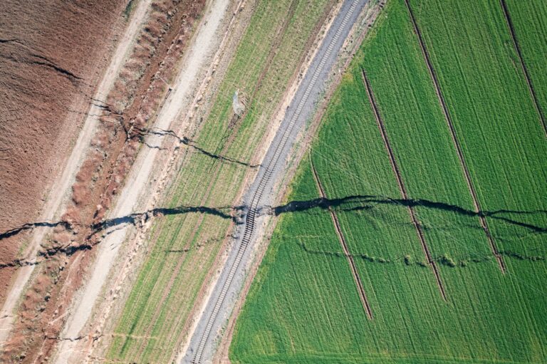
The Dead Sea Fault, at the boundary of the Arabian and Sinai plates, runs south to north from the Red Sea, through Gulf of Aqaba near NEOM, and into Syria. The northern area of this fault connects to the fault system responsible for the devastating earthquakes in southern Turkey in February 2023.
“There are discrepancies in the estimated slip rates in different sections of the Dead Sea Fault,” says Li. “Existing models suggest a slip rate of 4-6mm per year along the entire length of the fault, but this doesn’t account for inconsistencies between the observed movement of structures and the slip-rate estimates for the northern area of the fault.”
These discrepancies have introduced uncertainties for seismic hazard and risk analysis in the region. Accessing the Syrian section of the Dead Sea Fault has been impossible since 2010 due to ongoing conflict, and so the project team used satellite radar images instead. They made new advances with a technique called “burst-overlap interferometry,” where images of each area, taken at regular intervals from 2014-2021, were laid on top of one another to create displacement maps.
“This technique had primarily been used on meter-scale seismic displacements before,” says Jónsson. “Li’s extraordinary work takes it down to the millimeter scale, which is exciting! She determined slip rates even though parts of the northern Dead Sea Fault are covered in vegetation, which can disturb the satellite radar measurements.”
They estimate the slip rate of the northern Dead Sea Fault at 2.8mm per year, while the southern Dead Sea Fault matches previous studies at around 5mm per year. “The observed movement of geological features in the north could be due to earthquake clustering over the past 3500 years. The resulting jolts had led to an overestimation of the annual slip rate,” says Li.
“It seems the northern Sinai plate moves separately from the main Sinai plate in the south. We think the northern Sinai plate actually forms a separate small plate, the Latakia-Tartus microplate,” adds Jónsson. “Due to the lower slip rate, the seismic hazard associated with the northern Dead Sea Fault is markedly lower than previously thought.”
Reference
- Li, X., Jónsson, S., Liu, S., Ma, Z., Castro-Perdomo, N., Cesca, S., Masson, F. & Klinger, Y. Resolving the slip-rate inconsistency of the Northern Dead Sea fault. Science Advances, 10 p.eadj8408 (2024).| article
ABOUT THE AUTHOR
Xing Li
Alumna

You might also like
Earth Science and Engineering
Carbon sequestration for arid regions overcomes water constraints
Earth Science and Engineering
Asymmetric surface deformations reveal ongoing processes after earthquakes

Earth Science and Engineering
Depleted oil fields offer hydrogen storage sites
Earth Science and Engineering
When Earth breaks the “rules”

Earth Science and Engineering
Unearthing Arabia’s ancient foundations: New insights from the Ha’il terrane

Earth Science and Engineering
Sensing color cues to monitor coral health in the Red Sea
Earth Science and Engineering
Kahramanmaraş earthquake study showcases potential slip rate errors

Chemical Engineering