Earth Science and Engineering
Solving the salt problem for seismic imaging
Automated imaging of underground salt bodies from seismic data could help streamline oil and gas exploration.


The efficient extraction of oil and gas from within the Earth’s crust requires accurate images of subsurface rock structures. Some materials are hard to capture, so KAUST researchers have developed a computational method for modeling large accumulations of subsurface salt, a challenging material to derive accurately from seismic imaging data.
Seismic imaging involves sending soundwaves into the ground, where they will be reflected at boundaries between rock structures. Scientists analyze the reflected soundwaves to determine subsurface rock types and formations, and to pinpoint fossil fuel reservoirs.
However, in some regions, such as the Gulf of Mexico, the subsurface is peppered with salt bodies, which are huge accumulations of salt formed millions of years ago deep inside the Earth. Salt is a low-density, buoyant substance, meaning that salt bodies gradually rise through the Earth’s crust over time. This causes stress-related complexities between the salt and the surrounding rock layers. Furthermore, the salt’s crystal structure means that soundwaves are reflected at random, and there are no useable low frequencies retained in the seismic data.
“Data from salt zones are presently analyzed by highly trained experts rather than modeled by a computer,” explains Mahesh Kalita, a KAUST Ph.D. student in Tariq Alkhalifah’s group. “This is a time-consuming and expensive process that carries the risk of human error. We’ve developed a robust computational method for interpreting seismic data from salt bodies quickly and more accurately.”

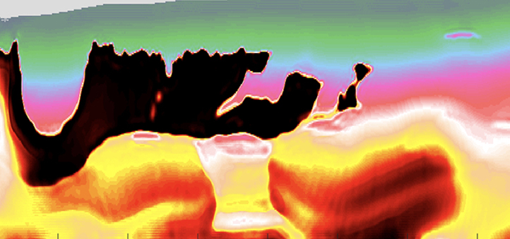
This figure illustrates the success of the proposed model (d) to reconstruct the target model (a) from a poor initial model (b). Figure c) shows how the traditional FWI model failed to reconstruct the target model. The black area represents the salt region.
© 2019 Mahesh Kalita
Existing models use a technique called full waveform inversion (FWI) to minimize the disparity between observed and modeled data. However, the lack of low frequencies in soundwave data from salt bodies means that a traditional FWI fails. Kalita and the team developed a two-part optimization process to refine FWI for salt body imaging.
“For the topmost layer of salt, we get a good enough signal to determine where the salt body begins, but then the soundwave energy rapidly disperses,” says Kalita. “Our technique takes the initial data from this top layer and ‘smears’ it across the most likely area that the salt body encompasses. We call this technique ‘flooding’.”
The resulting model is then tested alongside observed data to check that the surrounding rock structures match up and to ensure the model has not been “over-flooded.” Initial trials using a 1990s dataset from the Gulf of Mexico showed promise, with the new technique generating an accurate representation of local salt bodies.
“We will next trial our automated technique on recent, high-quality datasets that incorporate more three-dimensional details,” says Kalita.
References
-
Kalita, M., Kazei, V., Choi, Y. & AlKhalifah, T. Regularized full-waveform inversion with automated salt-flooding. Geophysics 84, 1-74 (2019).| article
ABOUT THE AUTHOR
Mahesh Kalita
Ph.D. Student

You might also like
Earth Science and Engineering
Carbon sequestration for arid regions overcomes water constraints
Earth Science and Engineering
Asymmetric surface deformations reveal ongoing processes after earthquakes

Earth Science and Engineering
Depleted oil fields offer hydrogen storage sites
Earth Science and Engineering
When Earth breaks the “rules”
Earth Science and Engineering
Unearthing Arabia’s ancient foundations: New insights from the Ha’il terrane
Earth Science and Engineering
Sensing color cues to monitor coral health in the Red Sea
Earth Science and Engineering
Kahramanmaraş earthquake study showcases potential slip rate errors
Chemical Engineering