Earth Science and Engineering
Assessing Red Sea potential for alternative energy
Advanced numerical models are helping researchers identify potential sites to exploit offshore wind and wave energy in the Red Sea region.
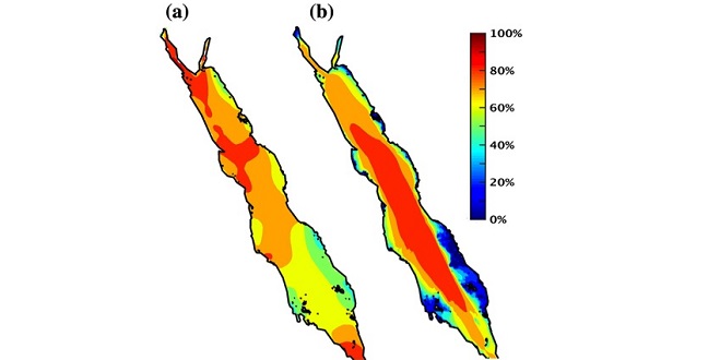
Occurrences of exploitable (a) wind speed and (b) significant wave height based on 18 years of hourly reanalysis data.
© 2016 KAUST
Potential wind and wave energy harvesting sites have been identified by KAUST researchers at three separate locations in the northern, central and southern Red Sea.
The team used two numerical models to simulate past climate and wave conditions in the region covering the time period from 1997 to 20141. The data suggests that wind and wave energy in the Red Sea is variable in different locations and across time.
Ocean energy in the form of waves and offshore winds are a potential source of alternative energy, but the high cost of construction means that careful analyses are required before infrastructure investments are made.
“Accurate wind and wave datasets are required for reliable assessment of energy potentials,” explained Ibrahim Hoteit, KAUST associate professor of Earth science and engineering from the University’s Physical Science and Engineering Division. “Numerical model outputs optimized with available observations in the region are the main source of information in regions such as the Red Sea where long-term in situ observations are not available.”
Despite the low energy generation potential of enclosed seas, energy converter devices set up in these areas are less exposed to severe climate conditions, making them easier to maintain.
The team’s advanced computations provided high resolution wind and wave energy data that covers small timescales over relatively small geographical areas.
“No other source of data is available at this resolution for the Red Sea region,” noted KAUST Earth science and engineering Ph.D. student Sabique Langodan.
The three locations identified as potential energy harvesting sites were found to have distinct daytime variations in wind power that change with the seasons, and there were also considerable seasonal variations in the power densities in each area.
The mountain ranges bordering the Red Sea cause it to act like a virtual wind channel, with winds moving along its long axis. The northern location identified by the researchers is characterized by consistent winds due to the influence of the Mediterranean wind system, but more energetic winds and waves were found in the central Tokar region, where a 110 kilometer valley forms a gap that plays a role in creating a localized weather system.
“Although we locate the regions of high wind and wave energy potentials in the Red Sea, the harvesting will require further site studies,” said KAUST Professor of Applied Mathematics and Computational Science Omar Knio. “For instance, a convenient location for an offshore wind farm is determined by the accessibility from the shoreline, and we did not consider this in the present study. We also did not account for the uncertainty in wind or wave fields at the specific locations, which is nowadays described by ensembles of simulations.” This will be considered in a future study, Knio added.
References
- Langodan, S., Viswanadhapalli, Y., Dasari, H.P., Knio, O. & Hoteit, I. A high-resolution assessment of wind and wave energy potentials in the Red Sea. Applied Energy 181, 244-255(2016).| article
You might also like
Earth Science and Engineering
When Earth breaks the “rules”
Earth Science and Engineering
Unearthing Arabia’s ancient foundations: New insights from the Ha’il terrane

Earth Science and Engineering
Sensing color cues to monitor coral health in the Red Sea
Earth Science and Engineering
Kahramanmaraş earthquake study showcases potential slip rate errors

Chemical Engineering
Unveiling the role of biomass-burning aerosols in atmospheric reactions

Earth Science and Engineering
Feeling the heat across the Middle East
Applied Mathematics and Computational Sciences
Past and future drought patterns across the Arabian Peninsula
Earth Science and Engineering


