Earth Science and Engineering
West Africa warms but airborne dust keeps the Red Sea cool
World-class computing facilities at KAUST enable researchers to tackle complex questions in climate science and oceanography.


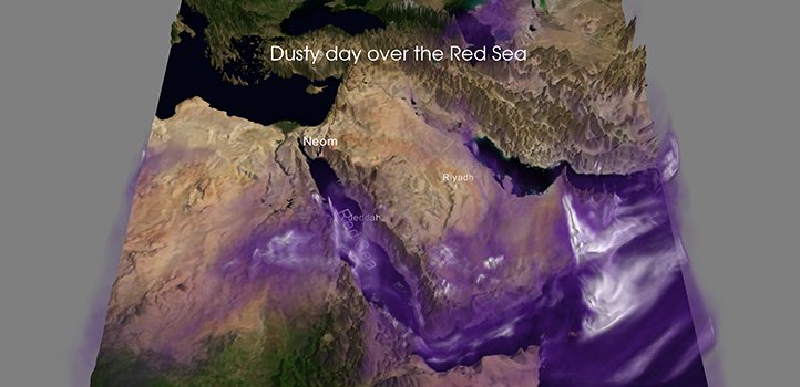
KAUST researchers reveal how the Red Sea’s location in a dust trap affects the regional climate.
The Red Sea is located between North Africa and the Arabian Peninsula, the world’s largest dust source regions. Summer winds pump dust from the Sahara and Arabian deserts down a narrowing mountain-fringed passage, causing it to accumulate over the southern Red Sea. Dust suspended as aerosol particles in the atmosphere can influence climate by altering the balance between sunlight absorbed at the Earth’s surface and heat energy radiated back to space. This is known as radiative forcing.
“We show that summer conditions over the Red Sea produce the world’s largest aerosol radiative forcing1, and yet the impact of dust on the Red Sea was never studied— it was simply unknown,” says Sergey Osipov, postdoctoral fellow and co-author with his supervisor Georgiy Stenchikov. Simulations reveal that dust cools and freshens the Red Sea, potentially protecting coral reefs against the damaging effects of ocean warming due to climate change.

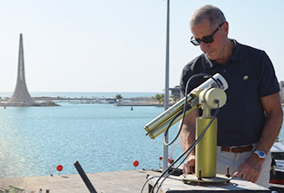
Georgiy Stenchikov and his research team (L-R)—doctoral students Evgeniya Predybaylo and Jerry Raj, and postdoc Sergey Osipov—reveal how the Red Sea’s location in a dust trap affects the regional climate.
© 2019 KAUST
A surprising finding relates to biological productivity. “Dust deposition adds nutrients,” explains Osipov. “However, we find that dust radiative forcing slows down the Red Sea circulation and reduces the main nutrient supply to the Red Sea through the Bab-el Mandeb strait. The net effect on overall bio-productivity remains to be established.”
Large volcanic eruptions, such as the 1991 eruption of Mount Pinatubo in the Philippines, inject vast amounts of sulfur dioxide into the upper atmosphere, where it is converted into tiny sulfate aerosol droplets. These sulphate aerosols spread around the globe, exerting a strong radiative forcing effect.
Osipov and Stenchikov previously showed that the Pinatubo eruption affected the regional climate of the Middle East and Red Sea2. They have now compared its impact with that of airborne dust1.
“We show the effects of Pinatubo and dust are greatest in the northern and southern Red Sea, respectively, having different effects on surface and deep-water cooling,” says Osipov.
Georgiy Stenchikov and his group focus their research on understanding the weather patterns of the Red Sea region.
© 2019 KAUST
World-class computing
The Middle East and North Africa is an extremely arid region, which is experiencing rapid climate and environmental change. Understanding the physical processes underlying the region’s strong natural climate variability is important for future climate projections, and for predicting droughts and famines.
“The region’s climate is highly complex, involving long-distance interconnections—teleconnections—and feedbacks that are difficult to capture in models,” says Stenchikov. “This is why we work on the problem using the advanced computer resources provided by KAUST’s Supercomputing Core Laboratory.
Osipov emphasized that the research would have been impossible without world-class computer resources provided by KAUST. This also applies to two other recent studies3,4, involving two other researchers in the group.
Doctoral student Evgeniya Predybaylo studies the impact of large volcanic eruptions on a major mode of natural climate variation called the El Niño‐Southern Oscillation (ENSO). ENSO drives extreme weather and climate events and even affects hurricane and tornado activity.
Forecasting ENSO events would help people prepare for possible collapses of fish stocks and agricultural crises, says Predybaylo. ENSO is notoriously difficult to predict, but volcanic eruptions may play a role. Interestingly, strong equatorial volcanic eruptions often coincide with an El Niño event, ENSO’s warm phase, but the relationship is complex and poorly understood,” says Predybaylo.
In simulations3, ENSO’s response partly depends on the eruption’s seasonal timing: summer eruptions induce stronger El Niños than winter or spring eruptions.
Ocean conditions prevailing at the time of the eruption also play a role. “Radiative forcing following large eruptions generally results in surface cooling,” explains Predybaylo. “However, the tropical Pacific often shows a warming response. We show that this is due to uneven equatorial ocean cooling and changes in trade winds.”
“A Pinatubo-size eruption may partially determine the phase, magnitude and duration of ENSO, but it is crucial to account for the eruption season and ocean conditions just before the eruption,” she concludes.
West Africa set for a warm change
Another KAUST climate modeling study reveals potential changes in the West African Monsoon (WAM) due to global warming4. Home to more than 300 million people, West Africa has an agriculture-based economy: its food security is affected by WAM, making it important to understand present and future variability.
“WAM is a difficult system to model because it involves a complex interplay of multiscale processes,” explains KAUST doctoral student, Jerry Raj. To simulate WAM under present and future climate, Raj used a sophisticated climate model able to account for convective rainfall, as well as larger-scale processes.
Their simulations indicate that West Africa will become generally hotter as a result of climate change—elevated areas of Sahel and western Sahara are projected to experience temperature increases of 4 degrees Celsius or more by the century’s end.
The simulations also indicate precipitation increases over the equatorial Atlantic and the Guinean coast, yet the southern Sahel appears drier. At the same time, western Sahara experiences a moderate increase in precipitation. Finally, WAM onset occurs earlier over the eastern part of the region, but is delayed over the western part.
“Climate projection is the first and the most important step toward adaptation policies aimed at avoiding damaging environmental and socio-economic consequences,” says Raj.
References
-
Osipov, S. & Stenchikov, G. Simulating the regional impact of dust on the Middle East climate and the Red Sea. Journal of Geophysical Research: Oceans 123, 1032–1047 (2018).| article
-
Osipov, S. & Stenchikov, G. Regional effects of the Mount Pinatubo eruption on the Middle East and the Red Sea. Journal of Geophysical Research: Oceans 122, 8894-8912 (2017).| article
- Predybaylo, E., Stenchikov, G. L., Wittenberg, A. T. & Zeng, F. Impacts of a Pinatubo-size volcanic eruption on ENSO. Journal of Geophysical Research: Atmospheres 122, 925 –947 (2017).| article
-
Raj, J., Bangalath, H. K. & Stenchikov, G. West African Monsoon: Current state and future projections in a high‑resolution AGCM. Climate Dynamics 52, 6441-6461 (2019).| article
ABOUT THE AUTHOR
Georgiy Stenchikov
Professor
You might also like
Earth Science and Engineering
Carbon sequestration for arid regions overcomes water constraints
Earth Science and Engineering
Asymmetric surface deformations reveal ongoing processes after earthquakes

Earth Science and Engineering
Depleted oil fields offer hydrogen storage sites
Earth Science and Engineering
When Earth breaks the “rules”
Earth Science and Engineering
Unearthing Arabia’s ancient foundations: New insights from the Ha’il terrane

Earth Science and Engineering
Sensing color cues to monitor coral health in the Red Sea
Earth Science and Engineering
Kahramanmaraş earthquake study showcases potential slip rate errors
Chemical Engineering