Environmental Science and Engineering
A leap forward in estimating crop water use
High-resolution imaging data collected by small satellites could transform how we monitor freshwater use in agriculture.


To conserve and manage fresh water, particularly in arid regions such as Saudi Arabia, it is important to understand how the water is used each day. KAUST scientists are using data gathered by shoebox-sized satellites, or CubeSats, to learn more about daily agricultural water use.
An estimated 90 percent of Saudi Arabia’s freshwater supplies are used in crop irrigation, but much of this comes from unsustainable aquifers. However, keeping track of water fluxes is incredibly difficult and there are no estimates tracking agricultural consumption by area over time.
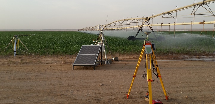
Farmers often uniformly irrigate their crops using pivots without paying specific attention to areas of the field that need more or less water. The team set up ground-based systems to collect evapotranspiration and local weather data to compare with the data derived from CubeSats.
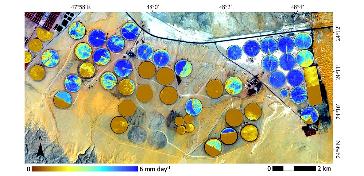
Reproduced from reference under a Creative Commons Attribution (CC BY) license @ 2018
“My work aims to estimate the amount of water used by crops using satellite imagery and readily available weather data,” says Bruno Aragon, at KAUST’s Water Desalination and Reuse Center, who conducted the research with coworkers at Planet and NASA’s Jet Propulsion Laboratory in the US, under the supervision of KAUST’s Matthew McCabe. “Using computer modeling techniques, we can then estimate transpiration from plants—the water that plants use to both grow and keep cool—and soil evaporation, the water lost to the atmosphere from the ground.”
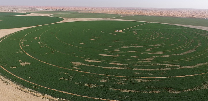
One of the fields in the study zone.
Reproduced from reference under a Creative Commons Attribution (CC BY) license @ 2018
CubeSats provide near-daily data at 3-meter pixel resolution, almost 100 times the level of spatial detail in other satellite data, such as those collected by Landsat 8. Building on their earlier work, in this project the team collected CubeSat data covering a small area of irrigated fields of maize in Saudi Arabia. They then used a machine learning program to correct the images for atmospheric variability and bring them up to research-grade standards.
The researchers put the images into the Priestley-Taylor Jet Propulsion Laboratory model, an existing model for measuring evapotranspiration. Aragon also modified the model to incorporate local environmental data, such as soil heat and moisture and air temperature.
“We evaluated model performance with data collected by equipment onsite on the ground,” says Aragon. “Our CubeSat-based model provided a good estimation of water use, similar to other satellite-based retrievals. Our technique has the clear advantage of vastly improved resolution and detail. The resolution and near-daily retrievals allow for the detection of specific events in crop development, significantly reducing the odds of missing important changes in individual fields.”
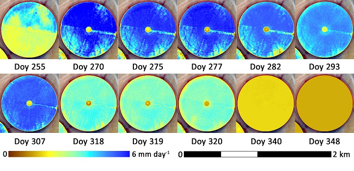
Crop development and water use for a specific maize pivot. The CubeSat imagery enables observation of the differences within the field for different planting dates for the upper and lower portions of the field.
Reproduced from reference under a Creative Commons Attribution (CC BY) license @ 2018
The team plan to improve their technique further. Better estimations of soil moisture could come from adding thermal or microwave imaging technology to the CubeSats, for example, and other important data to include crop type, height and vegetation biomass—all of which impact the amount of water needed at any given time.
Aragon will soon visit the Jet Propulsion Laboratory in California, researching model improvements for vegetation monitoring as part of a project linked to NASA’s ECOSTRESS sensor, which was recently installed on the International Space Station.
“The ECOSTRESS mission aims to track the biosphere response to water availability changes at a diurnal level: in other words, it tracks global plant stress throughout the day,” says Aragon. “I expect to learn a great deal on this placement that we can apply to our work on crop water use.”
References
-
Aragon, B., Houborg, R., Tu, K., Fisher, J.B. & McCabe, M.F. CubeSats enable high spatiotemporal retrievals of crop-water use for precision agriculture. Remote Sensing 10, 1867 (2018).| article
ABOUT THE AUTHOR
Bruno Aragón
Ph.D. Candidate

You might also like
Environmental Science and Engineering
Soil biodiversity is an overlooked frontline of disease prevention

Environmental Science and Engineering
Soil microbes are source of plastic-degrading enzymes
Environmental Science and Engineering
Bringing together the tools to harness the potential of microbial diversity
Environmental Science and Engineering
Climate action needs a tree change
Chemical Engineering
Natural solvents enable fully bio-based membranes

Environmental Science and Engineering
Plant diversity reduces the impacts of grazing pressure in drylands
Environmental Science and Engineering
Water-repelling surfaces reveal surprising charging effects
Environmental Science and Engineering