Environmental Science and Engineering
The sky’s the limit for Earth observation
Emerging technologies are poised to transform how we observe the Earth.


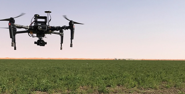

A quadcopter hovers above a paddock. A practical outcome of this technology is affordable, farm-scale aerial systems that offer real time monitoring of crops for farmers.
© 2017 Hydrology Agriculture and Land Observation team
Imagine sending your own custom-made satellite into space to study specific elements of rivers, glaciers, volcanoes, landslides or agricultural practices.
Sensors, digital imaging and other sensing components have shrunk in size and cost, which has dramatically changed the technology available to Earth scientists in just the last five years. KAUST researchers and international colleagues report that we are entering a new era in Earth observation and research; they identify what’s needed if we are to maximize its opportunities.
In 2016, Matthew McCabe from KAUST met with experts from across the globe for a workshop at Princeton University, USA, to examine the current state of Earth observation. They discussed existing and emerging technologies and how these might be utilized in the near future.
“One of the most exciting aspects of working in Earth observation currently is that the technology is cutting-edge,” says McCabe. “It is one of those rare instances where technology is not a constraint on scientific thought. In the past, we generally had to compromise between how well we could observe the earth and how often. With advances in sensors and systems, these spatio-temporal divides are gradually being removed. The potential for new research, applications and insights is huge, and is restricted only by our imagination!”
From the workshop came a paper, led by McCabe, that serves as a technological roadmap for future students and researchers. A wide range of research possibilities are canvassed: from harnessing and analyzing big data captured by satellites and unmanned aerial vehicles (UAVs), to monitoring events such as flash floods using high resolution, real-time video. A future of stratospheric balloons, continuous monitoring by solar planes and a global coverage of internet-enabled devices are reshaping how we observe and monitor the Earth.
While government space agency programs already contribute greatly to Earth observation, McCabe also highlights the value of working with burgeoning smaller-scale, commercial organizations. Currently he works with the private American company Planet, which creates custom-made shoe-box-sized satellites equipped with miniaturized sensors, at a fraction of the cost of space agencies. These budget satellites have the potential to fill gaps in current knowledge and enhance the available spatial and temporal coverage: Planet’s satellites, or ‘CubeSats’, can take multiple high-resolution snapshots of the Earth surface, at almost daily repeat times.
“With cost-reductions brought about by reusable rockets, individual investigators can realistically launch their own CubeSat! I’d love to put a KAUST satellite into space,” says McCabe. “Our most recent research uses UAVs to monitor the health of crops across farmers’ fields. Feasibly, we’re looking at affordable, farm-scale aerial systems that can tell the farmer precisely which parts of his crops need irrigating and when, the state of the crop in terms of disease, and many more elements all in near real-time. Combining UAVs with the global coverage of these small satellites could revolutionize agricultural practices around the world.”
But all these new technologies present new challenges: not least is the computational power needed to analyze and interpret the big data that these devices collect.
“We must train the next generation of Earth and environmental scientists to embrace the computational challenges inherent in big data — it’s not just raw computing power, we need machine learning and big data analytics tools that can interrogate the vast information reserves of this collected imagery,” says McCabe.
This remotely sensed data needs validation by equally strong sensing systems on the ground. Existing ground-based observation systems should be boosted with novel technologies that improve rainfall and stream-flow measurements, for example, or monitor real-time weather conditions during storms. Researchers should also leverage the internet of things, developing smart networks and heightening connectivity. One example is to engage the power of smart-phones and encourage the public to get involved in citizen science—a recent KAUST research project used a smartphone app to collect data on temperature and humidity in crowded spaces.
“Combining forces is the key—both in terms of the people we work with in research and the different levels of technology,” says McCabe. “It is a formidable jigsaw to put together, but I’m confident that we’ll rise to the challenge. We have a unique opportunity to reshape the nature of Earth observation, merging sophisticated tools and new data sources that can provide both real-time monitoring and deep scientific insights into the Earth and its processes.”
References
- McCabe, M., Rodell, M., Alsdorf, D.E., Miralles, D.G., Uijlenhoet, R. et al. The future of Earth observation in hydrology. Hydrology and Earth System Sciences 21, 3879-3914 (2017).| article
You might also like

Environmental Science and Engineering
Soil biodiversity is an overlooked frontline of disease prevention

Environmental Science and Engineering
Soil microbes are source of plastic-degrading enzymes

Environmental Science and Engineering
Bringing together the tools to harness the potential of microbial diversity

Environmental Science and Engineering
Climate action needs a tree change

Chemical Engineering
Natural solvents enable fully bio-based membranes

Environmental Science and Engineering
Plant diversity reduces the impacts of grazing pressure in drylands

Environmental Science and Engineering
Water-repelling surfaces reveal surprising charging effects

Environmental Science and Engineering