Environmental Science and Engineering
Diagnosing individual trees from above
Models based on images from unmanned aerial vehicles and satellites can help farmers to monitor the health of individual trees.


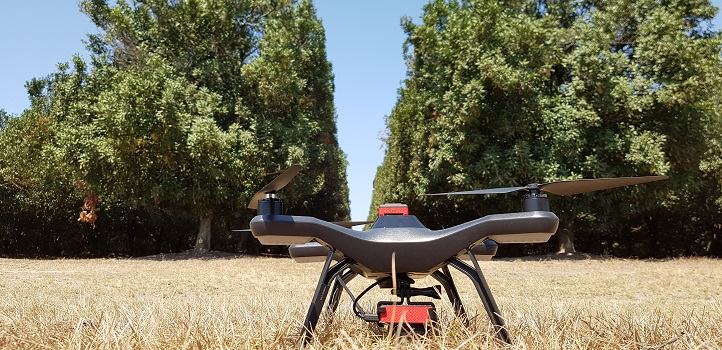
KAUST researchers are using combined data from satellite and unmanned aerial vehicle (UAV) flights to accurately map the condition of macadamia trees in Queensland. © 2020 KAUST
KAUST researchers are using combined data from satellite and unmanned aerial vehicle (UAV) flights to accurately map the condition of macadamia trees in Queensland. © 2020 KAUST
Increased data resolution makes it possible to scrutinize individual trees on a farm, which enables farmers to take targeted action. As the world’s population grows, it is vital to have improved ways to optimize food production. Remote sensing technologies are key to meeting these goals, providing the means to monitor crop health over large areas.
Researchers Kasper Johansen and Matthew McCabe, with co-workers in Australia, have demonstrated this potential using combined data from satellite and unmanned aerial vehicle (UAV) flights to accurately map the condition of macadamia trees in Queensland.
Macadamia nuts are an important export for Australia, but the trees take 15 years to mature and provide their maximum yield, so farmers must identify any trees that are suffering as early as possible. “Currently, macadamia farmers rely on manual visual assessment of each tree and its irrigation system, which is time consuming and often inconsistent,” says Johansen, “whereas UAV and satellite remote sensing could evaluate thousands at a time.”
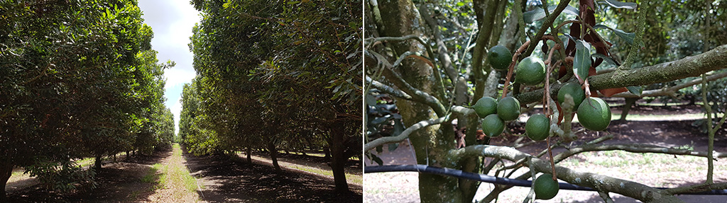
Macadamia trees (left) produce the valuable fruit, macadamia nuts (right).
© 2020 Kasper Johansen
The team studied three plantations containing trees of various ages and varieties. The health of each tree was assessed by an experienced agronomist using a five-point scale from excellent to poor condition. The researchers flew a UAV over the sites to record spectral images in green, red and near-infrared, and they acquired data across several more spectral bands from the Worldview-3 earth observation satellite.
Using training data from a few hundred trees, the team developed models relating the spectral data to the ground measurements. The models were then able to correctly classify over 98 percent of the other trees.
By combining data from UAV and satellite surveys, Johansen and co-workers were able to classify the health of individual trees on a five-point scale across large areas of macadamia plantations. Farmers can then use a map, like the one shown, to find and treat trees at risk. © 2020 Kasper Johansen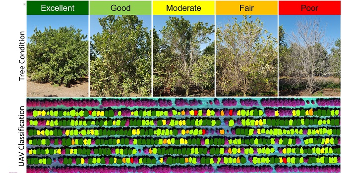
Interestingly, although the detailed spectra from Worldview-3 provided the most accurate models of tree health, the pixel size of 1.2 meters was too coarse to identify individual tree crowns, which could only be done with the high-resolution UAV data. This highlights the benefits of a combined UAV-satellite approach.
The research benefitted greatly from its links with McCabe’s research group at KAUST, which focuses on remote sensing applications for precision agriculture and includes related studies of olive orchards in Saudi Arabia.
“The use of remote sensing for precision agriculture, such as our study, will improve overall orchard management practices, production and yield,” says Johansen. “In turn, this will enhance food and water security.”
“This work was part of a collaborative project funded by the Australian government to support tree crop industries, specifically for macadamia, mango and avocado orchards,” explains Johansen.
References
- Johansen, K., Duan, Q., Tu, Y.-H., Searle, C., Wu, D., Phinn, S., Robson, A. & McCabe, M.F. Mapping the condition of macadamia tree crops using multi-spectral UAV and WorldView-3 imagery. ISPRS Journal of Photogrammetry and Remote Sensing 165, 28-40 (2020).| article
ABOUT THE AUTHOR
Kasper Johansen
Research Scientist

You might also like
Environmental Science and Engineering
Soil biodiversity is an overlooked frontline of disease prevention

Environmental Science and Engineering
Soil microbes are source of plastic-degrading enzymes
Environmental Science and Engineering
Bringing together the tools to harness the potential of microbial diversity
Environmental Science and Engineering
Climate action needs a tree change

Chemical Engineering
Natural solvents enable fully bio-based membranes

Environmental Science and Engineering
Plant diversity reduces the impacts of grazing pressure in drylands
Environmental Science and Engineering
Water-repelling surfaces reveal surprising charging effects
Environmental Science and Engineering