Statistics
Modeling the neighborhood boosts landslide prediction
A prediction model that considers multiple landslides over time in a given region may improve the accuracy of early warning systems.


An effective hazard warning system aims to predict the time, place, size and frequency of landslides, yet there are multiple complex and often random input factors to consider. Researchers have developed a computer model that improves on existing prediction accuracy and enhances understanding of the complexities inherent in landslide events.
“Existing landslide models work from a premise where each slope in an area is assigned a value of zero or one — the slope is either stable or unstable,” says former KAUST postdoc, Luigi Lombardo, now at the University of Twente in the Netherlands. This project builds on previous landslide models developed by Lombardo, continuing his collaboration with Raphaël Huser and the team from KAUST.
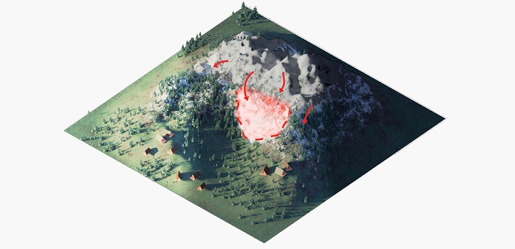
Improving prediction methods for landslides could give communities and disaster management agencies better warning systems, which could save lives. The red arrows show potential future landslide points; the red shaded area is a current hazard zone.
© 2020 KAUST
“Assigning a binary value means that critical details about a slope and its neighborhood are lost,” continues Lombardo. “For our model, we assigned values according to how many landslide events a given slope has experienced over time. In the case of our test region in the Collazzone area in Italy, this includes landslide data from detailed local records dating back around 100 years.”
Lombardo’s team focused on 3379 landslide events triggered by weather on 889 slopes over the 79 km2 area. A slope’s landslide propensity is influenced by multiple factors, such as geology, soil type and the slope’s gradient and shape, all of which act as input variables for the model.
“Predicting the size of individual landslides could transform warning systems.”
The researchers built five versions of the model, each with an increasing level of complexity, and trained each version using the Collazzone data. By including the frequency of individual slope failures and linking the slopes into ‘neighborhoods’ to incorporate how one slope’s behavior might influence other slopes nearby, their fifth and most complex model accurately predicted which Collazzone slopes would generate landslides and how often.
“Our model learns from successive events over time,” says Lombardo. “It learns not only from the physical characteristics of a given slope but also from the location of that slope and its neighborhood, and the previous behavior of that slope and the behavior of its neighbors. This level of detail is completely new to landslide modeling.”
Lombardo hopes that the model will be used to inform early warning systems. The model is transferrable and can be used in any region in the world, provided there is local landslide data available.
“I hope to take this model a step further and predict how large each landslide event could be,” says Lombardo. “While predicting landslide frequency is useful, predicting the size of individual landslides could transform warning systems and improve both land and hazard management.”
References
-
Lombardo, L., Opitz, T., Ardizzone, F., Guzzetti, F. & Huser, R., Space-time landslide predictive modelling. Earth-Science Reviews 209, 103318 (2020).| article
ABOUT THE AUTHOR
Luigi Lombardo
Alum

You might also like

Statistics
Checking your assumptions

Statistics
Internet searches offer early warnings of disease outbreaks

Statistics
Joining the dots for better health surveillance

Statistics
Easing the generation and storage of climate data

Statistics
A high-resolution boost for global climate modeling

Applied Mathematics and Computational Sciences
Finer forecasting to improve public health planning

Bioengineering
Shuffling the deck for privacy

Bioengineering