Environmental Science and Engineering
Monitoring precious groundwater resources for arid agricultural regions
A pioneering framework will monitor groundwater use for agricultural irrigation across Saudi Arabia.


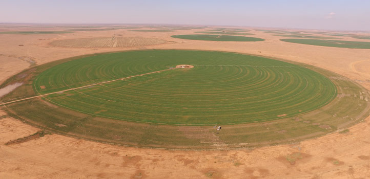
KAUST researchers have designed a framework in collaboration with the Saudi Ministry of Environment Water and Agriculture to provide detailed information on agricultural groundwater use in arid regions. © 2021 KAUST. /en/article/1079/monitoring-precious-groundwater-resources-for-arid-agricultural-regions
KAUST researchers have designed a framework in collaboration with the Saudi Ministry of Environment Water and Agriculture to provide detailed information on agricultural groundwater use in arid regions. © 2021 KAUST. /en/article/1079/monitoring-precious-groundwater-resources-for-arid-agricultural-regions
A framework designed to provide detailed information on agricultural groundwater use in arid regions has been developed by KAUST researchers in collaboration with the Saudi Ministry of Environment Water and Agriculture (MEWA).
“Groundwater is a precious resource, but we don’t pay for it to grow our food, we just pump it out,” says Oliver López, who worked on the project with KAUST’s Matthew McCabe and co-workers. “When something is free, we are less likely to keep track of it, but it is critical that we measure groundwater extraction because it impacts both food and water security, not just regionally, but globally.”
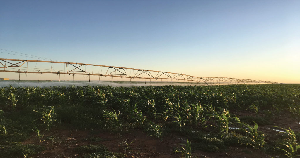
Saudi Arabia’s farmland is often irrigated via center pivots that tap underground aquifer sources. The team has built a powerful tool that captures details of water use from the regional scale down to individual fields. “This is the first operational system in the world for monitoring and modeling agricultural water use at such fine spatial and time scales,” notes López.
The framework combines data from several sources, including the Landsat 8 satellite, weather prediction models and a land-surface hydrology model, to enhance the system’s resolution and prediction accuracy.
The team at KAUST built a powerful operational system for monitoring and modeling agricultural water use at fine spatial and time scales.
© 2021 KAUST; Prof. McCabe’s HALO Research Group
“The satellite images show distinct patterns of active fields against the bare desert background, allowing us to identify individual center-pivot fields, even if they are irregular in shape and size,” says López.
The team derived crop evaporation rates, surface temperature and solar radiation reflection, and crop growing patterns from the satellite data. They combined this information with a regional surface hydrology model to estimate the amount of water delivered to each field by the center pivots.
They evaluated the framework at a small-scale 40-field experimental facility in Al-Kharj, before trialing it at the large scale in Al-Jawf province, where it successfully estimated water use in over 5,000 individual fields. The approach has since been applied nationally across more than 35,000 fields.
“Our framework has provided extensive field-scale estimates for 2015 that will serve as a benchmark for future comparisons,” says López. “We hope our model offers a consistent and reliable tool that demonstrates the impact of water management policies and drives future decisions.”
The team plans to integrate multiple satellite data sources to improve data-collection frequency and resolution, thus improving the framework’s accuracy.
“A key goal of our research group is to monitor ‘every field, everywhere, all the time’ — a true big data analytics problem,” says McCabe. “To address national and global food and water security concerns, we need local-level knowledge, delivered at the planetary scale.”
References
- López Valencia, O.M., Johansen, K., Solorio, B.J.L.A., Li, T., Houberg, R., Malbeteau, Y., AlMashharawi, S., Altaf, M.U., Fallatah, E.M., Dasari, H.P., Hoteit, I. & McCabe, M.F. Mapping groundwater abstractions from irrigated agriculture: big data, inverse modeling, and satellite-model fusion approach. Hydrology and Earth System Sciences 24, 5251-5277 (2020).| article
ABOUT THE AUTHOR
Oliver López
Postdoc

You might also like
Environmental Science and Engineering
Soil biodiversity is an overlooked frontline of disease prevention

Environmental Science and Engineering
Soil microbes are source of plastic-degrading enzymes

Environmental Science and Engineering
Bringing together the tools to harness the potential of microbial diversity

Environmental Science and Engineering
Climate action needs a tree change

Chemical Engineering
Natural solvents enable fully bio-based membranes

Environmental Science and Engineering
Plant diversity reduces the impacts of grazing pressure in drylands
Environmental Science and Engineering
Water-repelling surfaces reveal surprising charging effects

Environmental Science and Engineering