Electrical Engineering
Internet of underground things to reveal buried vistas
Pinpoint mesh of smart underground objects could give real-time 3D readout of fossil fuel reserves.
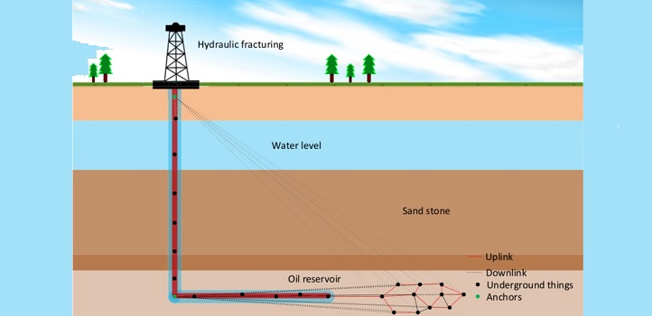
A subterranean system of networked sensors could give oil and gas industry operators the unprecedented ability to “see” deep below ground. KAUST researchers are working toward an internet of underground things (IoUT), which will enable precise, real-time monitoring of buried assets, including fossil fuel reservoirs.
“We believe that IoUT technology can lead to smart oil and gas fields with improved production processes,” says postdoctoral researcher Nasir Saeed, who worked on the project with group leader Tareq Al-Naffouri.
Electromagnetic signals used by mobile phones and wifi routers barely penetrate soil and rock, yet underground sensor networks can communicate by generating fluctuating magnetic fields, a process called magnetic induction. For the sensor data to be useful, however, operators need to know each sensor’s precise location in three-dimensional space around the reservoir.
Al-Naffouri and Saeed were part of a team that recently developed a method for pinpointing sensors in the deep ocean, another challenging environment. That technology involved sending light-based signals, which does not work through rock. “We have now proposed an accurate localization method to pinpoint smart objects under the ground,” Saeed says.
In previous work, researchers estimated the distance between neighboring underground sensors using parameters of the magnetic induction signal, such as signal strength and timing. However, the calculation used Euclidian distances, an approach that assumes all sensors are on a single plane below the ground, which is not appropriate because the sensors are at a range of depths. “The Euclidian distance may be much less than the actual distance between two sensors,” Saeed says.
So the team developed an algorithm that used geodesic distance, the shortest path between any two points on a curved surface. Although geodesic distance is usually used for measurements across the Earth’s surface, it works equally well for subsurface measurements. “Geodesic distance closely approximates the actual distance between sensors,” Saeed says. The team showed that using this new technique, they could achieve 30 percent better sensor localization accuracy.
The team revealed how various network parameters influence localization calculation accuracy. “The underground environment requires small, low-power smart objects; however, reducing the magnetic coil size and power can lead to low localization accuracy,” Saeed says. “It is crucial to analyze these tradeoffs before implementing actual IoUT networks. The next steps include building a practical demonstration IoUT network,” he says.
Real IoUT networks will probably use multiple communication modes, Al-Naffouri says. “The harsh underground signal propagation environment dictates the use of multiple technologies, which in addition to magnetic induction includes acoustic and electromagnetic signals.”
References
- Saeed, N, Alouini, M.-S. & Al-Naffouri, T.Y. 3D localization for internet of underground things in oil and gas reservoirs. IEEE Access 7, 121769 (2019).| article
You might also like
Bioengineering
Self-aware biosensors boost digital health monitoring
Bioengineering
Smart patch detects allergies before symptoms strike
Computer Science
Green quantum computing takes to the skies
Electrical Engineering
Micro-LEDs boost random number generation
Bioengineering
Sensing stress to keep plants safe
Computer Science
Sweat-sniffing sensor could make workouts smarter

Electrical Engineering
New tech detects dehydration by touching a screen
Electrical Engineering


