Marine Science
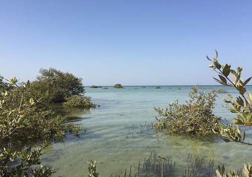
Coastal creep by Red Sea mangroves
Satellite imagery shows that the Red Sea’s mangrove forests have increased, not decreased, over the last 40 or so years.


Mangrove forests have many important roles in safeguarding our coastlines, and their status should be regularly monitored.
© 2016 KAUST
Mangroves are guardians of the coast, not only providing food and shelter for wetland animals, but also protecting against erosion and extreme weather. “Mangroves play a key role in coastal ecosystems, as nurseries and as carbon sinks.” says Hanan Almahasheer, a Ph.D. student from the KAUST Red Sea Research Center.
In a recent study, Almahasheer and colleagues assessed the status of the Red Sea’s mangrove forests—the world’s northernmost mangrove forests—using high-resolution aerial images taken by Landsat satellites in 1972, 2000 and 2013. Their results show that the area covered by the mangrove forests has expanded by 12 percent over the study period1.
This is in contrary to the belief of many experts that our planet has lost one-third of its mangrove forests since World War II due to urban development and intensified aquaculture. The situation becomes even more worrying considering that the decline is still occurring at an alarming rate of about 2.1 percent per year.
However, the Red Sea has experienced relatively less human activity than other places on Earth due to its harsh environment. This gives scientists a rare opportunity to examine the natural temporal variations of mangrove forests, which could help fine-tune their projections.
Almahasheer and her colleagues obtained Landsat satellite images and used them to create maps of Red Sea’s mangrove forests, including those occurring along the coastlines of Yemen, Africa and the Arabian Peninsula. Through the use of software, they determined the area covered by these forests, and also found (much to their surprise) that there was growth instead of decline over the last 40 or so years.
Specifically, the total coverage of Red Sea’s mangrove forests in 1972, 2000 and 2013 was 120, 132 and 135 km2, respectively. Much of the growth was due to rehabilitation projects along the African shores, including those in Yanbu in Saudi Arabia and in Hirgigo in Eritrea.
The findings demonstrate that afforestation efforts have an impact on mitigating mangrove decline. However, the researchers also found that coastal development, logging and camel grazing generally led to the loss of mangrove forests. In particular, the biggest decline occurred in Al Lith in Saudi Arabia, which is the site of one of the world’s largest shrimp farms. Mangrove forests in this area decreased from 2.33 km2 in 1972 to 0.18 km2 in 2013.
“This research is of great global significance, as mangrove ecosystems rank among the most threatened ecosystems globally,” noted Carlos Duarte, co-author of the work. “Our results show that the Red Sea, the area where mangroves were first described in Western science, has remained a relatively stable and sustainable ecosystem with losses balanced by gains through afforestation.”
References
- Almahasheer, H., Aljowair, A., Duarte, C. M. & Irigoien, X. Decadal stability of Red Sea mangroves. Estuarine, Coastal and Shelf Science 169, 164–172 (2016). | article
You might also like
Marine Science
Mapping movements of marine megafauna shows protection must go further
Marine Science
Red Sea coral absorbs chemical contamination
Marine Science
Buying time for coral reefs
Marine Science
Measuring spatial differences in reef-building corals to guide future management
Marine Science
Potential gains from replenishing reef fish stocks revealed
Marine Science
A place to trial hope for global reef restoration
Marine Science
Reef-building coral shows signs of enhanced heat tolerance

Marine Science