Computer Science
A breeding ground for successful start-ups
State-of-the-art facilities and world-class research projects give rise to thriving start-up companies based at KAUST.


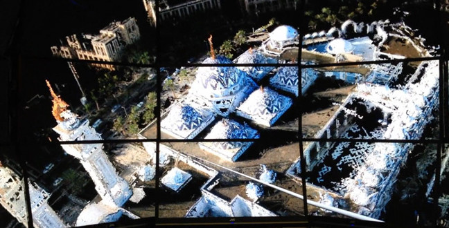

The team at FlaconViz were able to use unmanned aerial vehicles to produce detailed images of ancient parts of Jeddah.
© KAUST
Technological advances and exciting research at KAUST in recent years has led to the formation of several start-up companies through the Visual Computing Center (VCC) directed by Professor Wolfgang Heidrich. From interactive platforms for presenting Islamic history and culture, to autonomous drones generating 3D maps of entire city districts, KAUST’s researchers are at the forefront of new technology-based business.
A fine example of a start-up based at KAUST is FalconViz, led by Neil Smith, Mohamed Shalaby and PhD candidate Luca Passone and their team. The researchers have developed a new way of aerial surveying and mapping using high-resolution cameras attached to remote-controlled ‘quadcopters’, or unmanned aerial vehicles (UAVs). They successfully produced detailed maps of the ancient Saudi-Arabian city of Al-Balad within Jeddah. Jeddah was awarded World Heritage Site status by UNESCO in 2014.
Many of Al-Balad’s ancient buildings are in a poor state of repair and often unsafe for surveyors to access on foot. Traditional surveying methods are slow and painstaking, and there were concerns that, without intervention using new technology, significant information would be lost as the frail structures deteriorated.
The UAVs designed and built by FalconViz operate fifty meters above the ground, and are controlled by a pilot whose goggles allow him to sit in a ‘virtual cockpit’. When it came to creating images of Al-Balad, however, the team experienced some unexpected difficulties: “Al-Balad is a huge, highly congested old city,” describes Smith. “We tried flying one mission manually and found it was very easy to lose our bearings because all the buildings look very similar from the air. In order to systematically cover the entire 250,000 square-meter area, we had to invest significant time in creating detailed autonomous mission plans so that our UAV could fly over the area without the pilot.”
Each UAV is fitted with a high-resolution camera, and can quickly capture data of buildings and neighborhoods in great detail. Specialist imaging software then transforms the image data into detailed three-dimensional maps, plans and models. “We use ‘Structure-from-Motion’, a method of extracting a 3D structure from many overlapping digital images,” says Smith. “The algorithms use a change in camera position for each image to find the distance between them, triangulating the 3D positions of pixels in overlapping images. The more motion and movement around an area, the more complete the 3D model becomes.”
The cameras can also take continual video footage of the areas surveyed. The level of detail provided by FalconViz allows surveyors, historians and city planners to have views of cities they have never had before, and the technology has further far-reaching potential applications. “We hope our mapping and survey system will allow first responders to be more effective in disaster situations, by providing real-time maps of the disaster area, for example” explains Smith.
In a similar pursuit of preservation of history and culture, another start-up company at KAUST, led by Jens Schneider, provides computer applications for disseminating information about the religiously-significant city of Makkah and general information about Islamic culture to a wide audience. Through interdisciplinary research projects based at KAUST, the team developed platforms for mobile phones, computers, interactive information boards in museums, and even wearable computing technology such as augmented reality glasses. These applications provide virtual tours, interactive maps, and a host of information about the culture and history of Islamic cities. The team is now collaborating with organizations, from government ministries to small businesses, to provide customized hardware and software for smart cities of the future.
A third system, also developed by Schneider and colleagues, is also aimed at improving cities by monitoring crowds in real-time. Called HACHID, the system comprises easily-installed hardware and software that can be used to track and count people in high-density crowds gathering at mosques, airports or other public places. The researchers behind HACHID hope that it will prove invaluable in planning safe, large-scale events.
The creation and nurturing of these start-ups was made possible through the continued and substantial support of the Economic and Technology Development office at KAUST. These innovative companies will provide much-needed support for developing smarter cities and preserving sites of historical significance for future generations.
References
- | article
You might also like

Computer Science
Green quantum computing takes to the skies

Computer Science
Probing the internet’s hidden middleboxes

Bioscience
AI speeds up human embryo model research

Computer Science
Improving chip design on every level
Computer Science
Sweat-sniffing sensor could make workouts smarter

Computer Science
A blindfold approach improves machine learning privacy
Computer Science
AI tool maps hidden links between diseases

Bioscience